
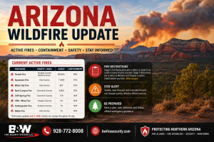
Arizona Wildfire Update: Active Fires and Containment
Updated: July 7, 2026
Arizona continues to see active wildfire activity across several counties, with fires ranging from large regional incidents to smaller starts being monitored by fire agencies. For the most current statewide fire activity, residents can check the Arizona Interagency Wildfire Prevention wildfire situation map, which links to incident reports, heat detections, InciWeb, and other official wildfire resources.
As of the latest available update, the largest active wildfire in Arizona is the Pocket Fire in the Sedona / Yavapai County region. Current fire map data lists the Pocket Fire at more than 26,000 acres, with containment changing as crews continue working the fire. Other Arizona fires being tracked include the Sycamore Fire in Gila County, the White Tail Fire in Gila County, the Rock Canyon Fire in Coconino County, the Cliff Spring Fire near the Grand Canyon area, the YRN – Mina Fire in Yavapai County, the Yellowjacket Fire in Graham County, and the Baldy Fire in Gila County.
Because acreage, containment, smoke impacts, road closures, and evacuation levels can change throughout the day, readers should always verify the latest information through official emergency sources such as the Arizona Emergency Information Network, Arizona Department of Forestry and Fire Management, InciWeb, and local county emergency management offices.
Current Active Arizona Wildfire Updates
| Fire Name | County / Area | Approx. Acres | Containment | Current Update |
|---|---|---|---|---|
| Pocket Fire | Yavapai County / north of Sedona area | 26,000+ acres | Changing as crews progress | This is currently the largest tracked wildfire in Arizona. Residents near Sedona, Oak Creek Canyon, Flagstaff, and surrounding areas should continue watching official updates for smoke, road impacts, and evacuation changes. Current tracking can be checked through the Pocket Fire incident map and official emergency sources. |
| Sycamore Fire | Gila County | Approx. 11,900 acres | Mostly contained | This fire is listed as mostly contained, but crews may still monitor hot spots, secure fire lines, and watch for flare-ups during dry or windy conditions. Statewide fire activity can be monitored through the Arizona wildfire situation map. |
| White Tail Fire | Gila County | Approx. 857 acres | Nearly contained | This fire is nearly contained. Even with high containment, nearby residents should avoid the area and continue following local agency updates and fire restrictions. |
| Rock Canyon Fire | Coconino County | Approx. 4,800 acres | Mostly contained | This northern Arizona fire is listed as mostly contained, but smoke, access limits, or crew activity may continue depending on conditions. |
| Cliff Spring Fire | Coconino County / Grand Canyon area | Approx. 170 acres | Not fully reported | This smaller fire is being tracked in northern Arizona. Travelers and residents near Grand Canyon-area roads, recreation areas, or forest lands should check official updates before heading out. |
| YRN – Mina Fire | Yavapai County | Approx. 24 acres | Not fully reported | This is a smaller Yavapai County incident. Local residents should continue to monitor county alerts and official wildfire sources. |
| Yellowjacket Fire | Graham County | Approx. 19 acres | Not fully reported | This is a small fire currently being tracked in Graham County. Even small fires can grow quickly in dry, windy conditions. |
| Baldy Fire | Gila County | Approx. 15 acres | Not fully reported | This is a smaller Gila County fire. No full containment update was listed in the latest statewide fire map data. |
Fire Restrictions Remain in Effect
Fire restrictions remain in place across much of Arizona. The Arizona Department of Forestry and Fire Management fire restrictions page lists current restriction information for State Trust Lands. As of the latest update, Stage 2 fire restrictions are in effect on State Trust Lands in several Arizona counties, while Stage 1 restrictions are in effect on State Trust Lands in Mohave and Yavapai counties.
For restriction information across state, federal, tribal, and local lands, residents can also use Arizona Interagency Wildfire Prevention. Restrictions can vary depending on whether you are on city, county, state, federal, tribal, or private land, so always check the rules for your exact location before camping, burning, welding, grinding, shooting, or using anything that could create sparks.
Evacuation Readiness: Know Ready, Set, Go
Arizona uses the Ready, Set, Go evacuation model to help residents understand what to do during wildfire threats.
READY means prepare now.
SET means be alert and ready to leave.
GO means evacuate immediately.
Do not wait until you see flames. If your area is placed under a GO order, leave immediately and follow directions from law enforcement, fire officials, and emergency management.
What Residents Should Do Now
Residents and business owners should continue to monitor official updates, especially if they live or work near Prescott, Prescott Valley, Sedona, Flagstaff, Chino Valley, Camp Verde, Payson, Globe, or other wildfire-prone areas.
Now is the time to:
Sign up for local emergency alerts
Keep vehicles fueled
Prepare a go-bag
Know evacuation routes
Follow fire restrictions
Avoid outdoor burning or spark-producing work
Keep phones charged
Check on family, neighbors, pets, and employees
Make sure fire alarms, fire sprinklers, extinguishers, cameras, and security systems are working properly
If you see flames, heavy smoke, or immediate danger, call 911. For current statewide emergency information, visit the Arizona Emergency Information Network.
B&W Fire Security Systems LLC helps Northern Arizona homes and businesses stay prepared with fire alarm systems, fire sprinkler systems, monitoring, inspections, fire extinguishers, security systems, cameras, and access control.
Call 928-772-8008 or visit https://bwfiresecurity.com/ to request service.